WATER IN THE OCEANS.
We have to distinguish between the concepts of ocean and sea:- ocean, a body of water that separates the continents.
- sea, an extension of one ocean, usually close to the coast.
 |
| Atlantic Ocean. |
 |
| Mediterranean Sea. |
1. 1. Oceans waters.
Oceans covers around a 71% of the Earth's surface and oceanic waters suppose about a 97% of the Earth's water. These waters are salines waters because the rivers carry rocks and salts to the sea.Its salinity depends of two factors:
- Water in landlock seas are saltier.
- Water in warmer latitudes because the heat causes more evaporation.
1. 2. Water in movement.
Seawater is constantly moving. There are three types of movements of oceanic waters:- Waves, is the up and down movement of the surface of the ocean caused by the wind.
- Tides, are the rising and falling of the sea level caused by gravitational pull of the Moon. When the sea level rises, it is high rise, when the sea level is low, it is low tide.
- Ocean currents are like big rivers moving within the oceans. It causes is the differences of salinity and temperature between the different parts of the ocean. Can be:
- Cold when the water inside the current is colder than the water around it.
- Warm, when the water is warmer.
3. FRESH WATER.
Less than 3% of the water on Earth is fresh water. Of this three percent, around a 70% is located in glaciers, 29'6% is located is groundwater and only a 0'4% is found in rivers and lakes.3. 1. River and lakes.
- A river is a flowing stream of water.
- Flow is the amount of water that a river carries.
- The flow regime are the changes in the flow of the river during the year.
- Upper course, the river flows in the mountains. Here flows very fast.
- Middle course, the river flows through flat lands. The speed of the current is slower and the current of the river bends, forming meanders. A meander, is a bend in the course of the river formed by the accumulation of sediments.
- Lower course, the river flows into the sea.
 |
| Upper course. |
 |
| Middle source. |
 |
| Lower course |
- Lakes are permanent bodies of water. Its water comes from rainfall, rivers and groundwater.
Groundwater.
Groundwater is water that flows under the surface.Aquifers are underground rivers. Its water comes from rainfall and them feed the rivers.
Aquifers are vulnerable to pollution and overuse.
Icebergs and glaciers.
Most of the freshwater on Earth is frozen.Criosphere includes all the ice in the world: ice caps and glaciers.
- Glaciers, large acumulation of frozen water. Them have two main parts:
- Cirque, a steep bowl-shaped depression which form the head of the glacier.
- Tongue, a narrow extension of ice projecting from the glacier cirque.

Water in the atmosphere.
Most of the water in the atmosphere is found is its lower part, the troposphere.Use of water.
The main uses of water are:- Domestic consumption.
- Agriculture, an 80% of the water is used in it.
- Urban underground deposits for cleaning and irrigation services.
- Energy production.
- Tourism.
4. THE DISTRIBUTION OF WATER ON OUR PLANET.
Earth has five oceans divided by the continents and rivers and lakes are found on the different continents.4. 1. Oceans.
 |
| World's oceans. File: Los océanos. http://recursostic.educacion.es/bancoimagenes/web/ Author: José Alberto Bermúdez. License: CC BY-NC-SA 3.0 |
- The Atlantic Ocean is the shallowest and has many seas such as the Mediterranean and the Bay of Biscay.
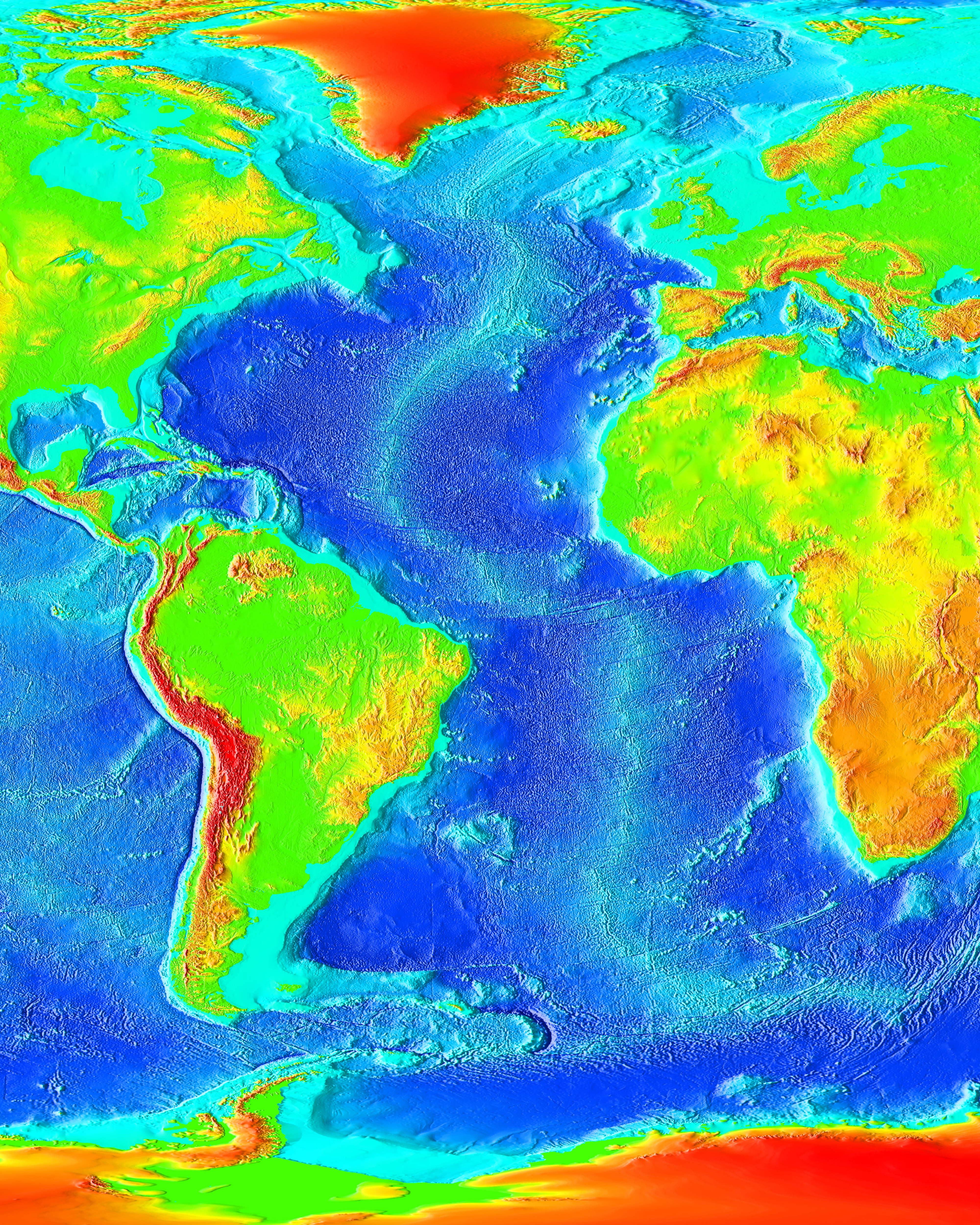
- The Pacific Ocean contains hundreds or archipielagos and experiences frequent volcanic eruptions.
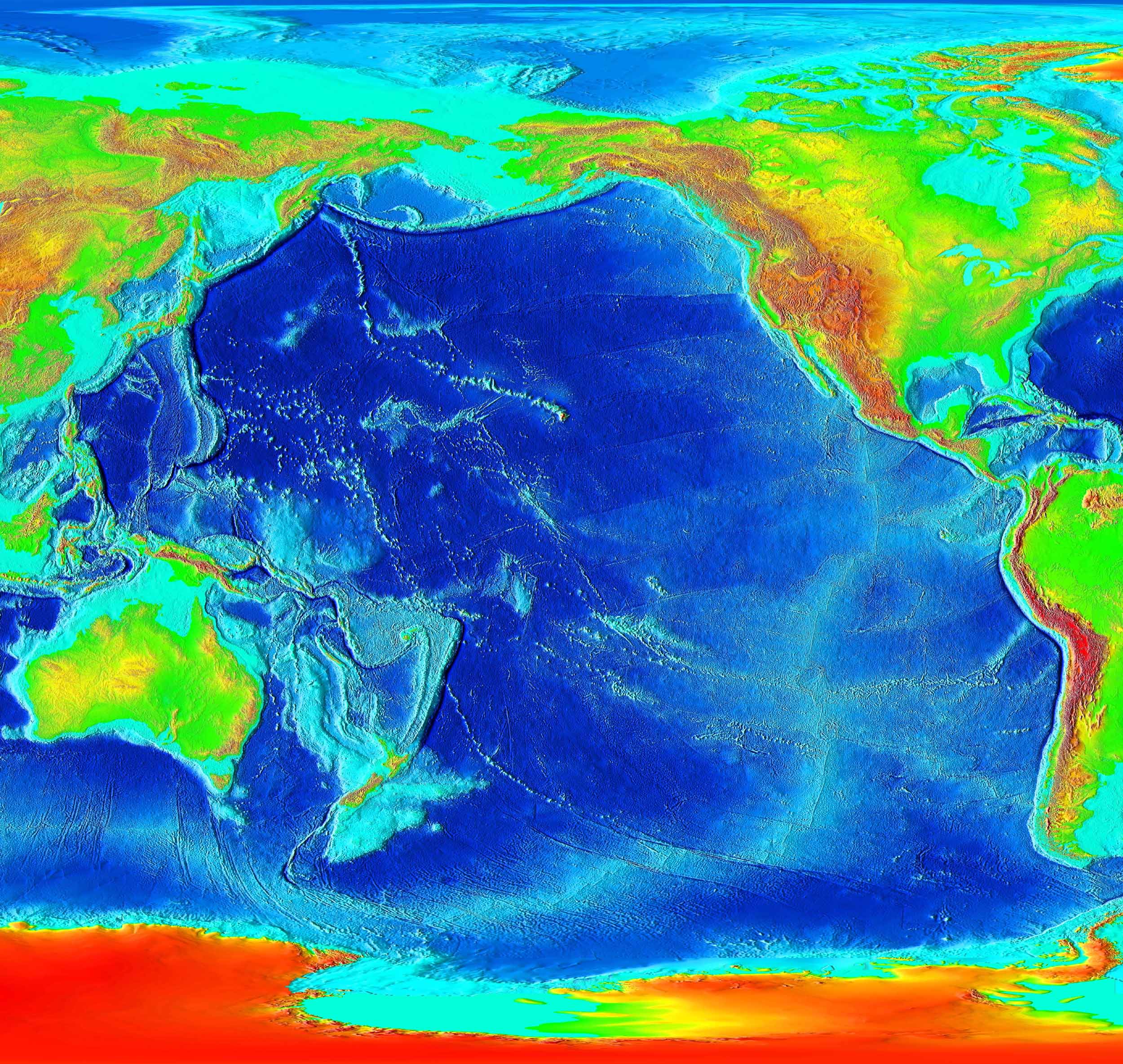
- The Indian Ocean.
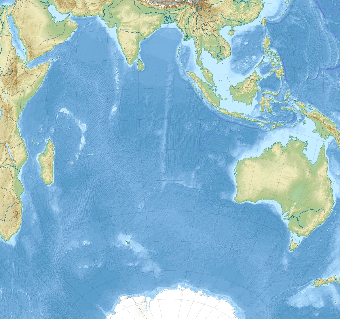 |
File:Indian Ocean laea relief location map.jpg https://commons.wikimedia.org/wiki/File:Indian_Ocean_laea_relief_location_map.jpg https://commons.wikimedia.org/wiki/User:Uwe_Dedering
CC BY-SA 3.0 |
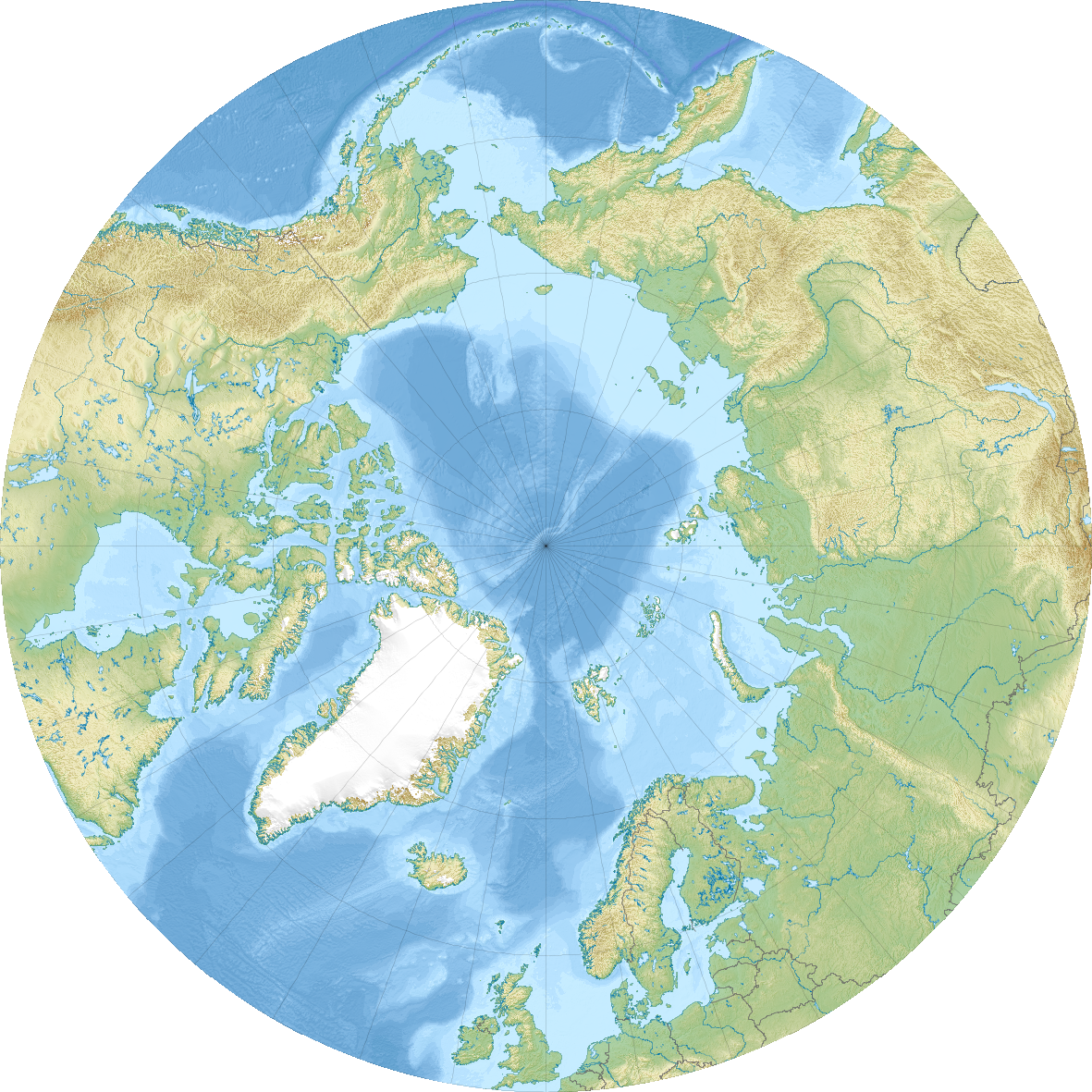
- Antartic and Artic Oceans surround the Earth's poles.

4. 2. Asian rivers and lakes.
The most important rivers of Asia are:- siberian ribers: the Ob, the Yenisei and the Lena.
- rivers that flow into the Pacific Ocean: the Amur, the Huang He, the Chang Jiang, the Mekong.
- rivers that flow into the Indian Ocean: the Ganges and the Indus.
- The Caspian Sea, the biggest lake on the world, the Aral Sea and the Lake Baikal (the deepest in the world).
- the Arabian Sea and the Sea of Japan.

 |
| Baikal Lake frozen. |
 |
| Road over the frozen Lena river. File: https://commons.wikimedia.org/wiki/File:Lena_River_Ice_Road.jpg Author: https://www.flickr.com/people/61591788@N00 |
 |
| The Lena river during the summer. File: Lena River in Biakal-Lena Zapovednik Author: CC BY-SA 4.0 |
 |
| The Huang-He's lower course. It is known also as the Yellow river due to the large amount of sediments and sand that the river carries. https://upload.wikimedia.org/wikipedia/commons/4/4f/Yellow_river_-_A._Holdrinet.jpg User: André Holdrinet. CC BY-SA 3.0 |
4. 3. America.
- The most important rivers are: the Yukon, the Mackenzie, the Mississippi-Missouri, the Río Grande, the Orinoco, the Amazon river (the river with the highest flow in the world) and the Paraná-Paraguay.
- The most important islands are Greeenland and Cuba.

4. 4. Africa.
African rivers are very long and carry a high volume of water. The main rivers are: the Nile (the longest river in the world with 6.670 km), the Niger, the Congo, the Zambezi and Orange.
There are several lakes of two types:
- located in basins (Victoria, Chad).
- located in fractures in the terrain (Albert, Tanganyka and Malawi).
- Islands: Madagascar.
- Gulfs: Guinea.
- Capes: Good Hope.

 |
| Egypt as seen from space at night. More than a 90% of the population of Egypt lives along the Nile's river valley, because of this, Egypt has been called since ancient times "a gift from the Nile". |
4. 5. Oceania.
The most important lake is Lake Eyre in Australia. It is salty.
The most important rivers are the Darling and the Murray.
The most important feature of the coastal relief is the Gulf of Carpentaria.
The most important feature of the coastal relief is the Gulf of Carpentaria.

4. 6. Antarctica.
Antarctica is completely cover by a layer of ice 2.000 meters deep.5. RIVERS AND LAKES OF EUROPE.
We can distinguish several hydrographic basins in Europe according to the ocean or sea in which the rivers flow into:- Artic rivers, such as the Dvina.
- Atlantic rivers, such as the Elbe, the Rhine, the Thames, the Seine, the Loire, the Garonne and the Tagus.
- Mediterranean rivers: the Rhone, the Tiber and the Po.
- Black Sea rivers: the Danube, the Dnieper and the Don.
- Caspian Sea rivers: the Ural and the Volga.

ACTIVITIES.
1. REVIEW GAME.


2. HANGMAN.
1. A long river located in North America. Its course join with the course of the Mississippi river.
__ __ __ __ __ __ __ __.
2. A river located in the Indochina Peninsula.
__ __ __ __ __ __.
3. An african lake located in a elongated depression.
__ __ __ __ __ __ __ __ __.
4. An australian lake. It is only fill with water when its rains.
__ __ __ __.
3. Fill the blank spaces.

4. WORLD'S OCEANS. Identify the names of the different oceans and the seas that appear in the map.

SOLUTIONS.
1.


2. HANGMAN.
1. A long river located in North America. Its course join with the course of the Mississippi river.
MISSOURI.
2. A river located in the Indochina Peninsula.
MEKONG
3. An african lake located in a elongated depression.
TANGANYKA.
4. An australian lake. It is only fill with water when its rains.
EYRE.3. Fill the blank spaces.

4. OCEANS OF THE WORLD.

puedes poner otro video de como se forma las olas?
ResponderEliminarde assa
EliminarAssa, I have included another video about the formation of the waves.
Eliminarthank you very much Abrahan
EliminarHi Abraham! I am Claudia os 1A and I have a question for the exam, in the papers you gave us it also includes some gulf, Do I have to study them for the exam?
ResponderEliminarYes, but you only have to know about the Gulf of Guinea in Africa and the Gulf of Carpentaria in Australia. Also, remember that the exam will include a question about the relief of Europe. Good luck!
Eliminar