Etiquetas

1ºBACHILLERATO (2) 1ºBACHILLERATO PENDIENTES (6) 1ºESO (111) 1ºESO GEOGRAFÍA GEOGRAPHY RECUPERACIÓN (1) 2018-2019 (2) 2ºESO (1) 3ºESO (31) 4ºESO (13) 4ºESO UNIDAD 2. LAS REVOLUCIONES LIBERALES UNIDAD 3. LA REVOLUCIÓN INDUSTRIAL. HISTORIA (1) ACTIVIDADES (1) ADAPTACIÓN CURRICULAR (3) ADAPTACIÓN CURRICULAR. (2) ANCIENT (1) ANCIENT EGYPT (1) ANCIENT GREECE (2) BILINGUAL (57) BYZANTIUM (1) CHARLEMAGNE (1) EGIPTO (3) Geografía (39) GEOGRAPHY (35) GRECÍA (1) GREECE (2) HISTORIA (54) HISTORIA MODERNA (1) HISTORIA. UNIDAD 8. MESOPOTAMIA. (1) HISTORY (24) HISTORY UNIT 7 PREHISTORY (1) IBERIAN PENINSULA (1) LA GANADERIA (2) LA PESCA Y LA SILVICULTURA. (1) MANUEL DE FALLA (5) MESOPOTAMIA (4) PENDIENTES (1) PREHISTORIA (2) PREHISTORY (1) RECUPERACIÓN (3) RESUMEN. (1) ROMA (2) ROME (2) TALLER DE AMPLIACIÓN. (1) TEMA 5. EL IMPERIALISMO Y LA PRIMERA GUERRA MUNDIAL. (1) THE EARTH'S BIOCLIMATES (1) UNIDAD 1. EL SIGLO XVIII (2) UNIDAD 10. EL RENACIMIENTO (4) UNIDAD 10. LA ANTIGUA GRECIA (2) UNIDAD 10. LAS PRIMERAS CIVILIZACIONES (2) UNIDAD 10. LAS PRIMERAS CIVILIZACIONES: MESOPOTAMIA Y EGIPTO. (4) UNIDAD 10. LAS PRIMERAS CIVILIZACIONES. (1) UNIDAD 11. ANTIGUA GRECIA. (1) UNIDAD 11. LA CIVILIZACIÓN GRIEGA. (1) UNIDAD 11. ROMA. (2) UNIDAD 12. COLONIZACIONES Y PUEBLO PRERROMANOS (1) UNIDAD 12. EL AUGE DEL IMPERIO DE LOS AUSTRIAS. (2) UNIDAD 2. EL RELIEVE DE LA TIERRA. (7) UNIDAD 2. LA ORGANIZACIÓN ECONÓMICA DE LAS SOCIEDADES. (7) UNIDAD 2. LAS REVOLUCIONES LIBERALES (1) UNIDAD 2. LAS REVOLUCIONES LIBERALES. (2) UNIDAD 3. EL RELIEVE DE LOS CONTINENTES (1) UNIDAD 3. LA AGRICULTURA (7) UNIDAD 3. LA HIDROSFERA: AGUA DULCE Y AGUA SALADA (4) UNIDAD 3. LA REVOLUCIÓN INDUSTRIAL (1) UNIDAD 4. ESPAÑA EN EL SIGLO XIX. (1) UNIDAD 4. LA ATMÓSFERA (1) UNIDAD 4. LA ATMÓSFERA. (4) UNIDAD 4. LA ESPAÑA DEL SIGLO XIX (1) UNIDAD 5. LOS CLIMAS DE LA TIERRA. (1) UNIDAD 6. EL MUNDO DE ENTREGUERRAS. (1) UNIDAD 9. EGIPTO (2) UNIDAD 9. EL NACIMIENTO DEL MUNDO MODERNO. (5) UNIDAD 9. LA PREHISTORIA (1) UNIDAD 9. LA PREHISTORIA. (4) UNIDAD. 4 LA REVOLUCIÓN INDUSTRIAL. (1) UNIT 1. THE EARTH (1) UNIT 1. THE EARTH. (6) UNIT 1. THE FRAGMENTATION OF THE ANCIENT WORLD (1) UNIT 1. THE START OF THE MODERN AGE. (1) UNIT 10. THE FIRST CIVILIZATIONS. (2) UNIT 12. ANCIENT ROME (1) UNIT 2. THE EARLY MODERN AGE IN SPAIN AND AMERICA. (1) UNIT 2. THE EARTH'S RELIEF. (1) UNIT 2. THE EARTH'S SURFACE. (4) UNIT 2. THE PRIMARY SECTOR (1) UNIT 3. THE 17th CENTURY IN EUROPE. (1) UNIT 3. THE EARTH'S PHYSICAL CHARACTERISTICS. (7) UNIT 3. THE HYDROSPHERE. (1) UNIT 3. THE TERTIARY SECTOR. SPACE AND ACTIVITIES. (1) UNIT 4. THE ATMOSPHERE (2) UNIT 4. THE ATMOSPHERE. (1) UNIT 4. THE CLIMATE AND BIOCLIMATIC ZONES. (6) UNIT 5. THE EARTH'S BIOCLIMATES. GEOGRAPHY (1) UNIT 5. THE EARTH'S MAJOR BIOCLIMATIC ZONES. (3) UNIT 6. SPAIN'S PHYSICAL ENVIROMENT AND BIOCLIMATES. (1) UNIT 7. PREHISTORY (1) UNIT 7. PREHISTORY. (8) UNIT 8. THE FIRST CIVILIZATIONS. (2) UNIT 9. ANCIENT EGYPT (1) VISIGOTHS (1)

miércoles, 29 de noviembre de 2017

THE SECONDARY SECTOR. INDUSTRIAL SPACES.

1. THE SECONDARY SECTOR.

The secondary sector includes economic activities concerned with transforming raw materials into products that enable human needs to be meet. Includes:
  1. Industry.
  2. Mining.
  3. Energy production.
  4. Construction.

1. 1. Industry.

Industry is the activity that transforms raw materials into manufactured  products that are suitable for direct consumption or semi-finished materials that can be used as raw materials in other industrial processes.
Industry require three elements:
  1. Raw materials: natural resources that industry transform into products.
  2. Energy sources: natural resources that provide the force necessary to undertake industrial activities.
  3. Production factors. Them include:
  • labour force.
  • capital (physical and financial).
  • technology.

1. 2. Mining.

Mining is concerned with locating, extracting and refining rocks and minerals that are found on or beneath the surface.
Distribution of raw materials in the Earth's crust is very unequal, because of this mining uses:
  • prospecting methods: locate resources.
  • extraction techniques: obtain materials from open cast or subterranean mines.
  • refining systems: separate the mineral from the ore (the rock that contains it.

1. 3. Energy production.

Energy production transforms energy sources into heat and electricity. This pace in power stations that are specialised in different types of energy sources: thermal, nuclear, wind solar, etc.

1. 4. Construction industry.

Construction industry creates different types of structures and infraestructure. It requires plans and building materials.

2. CORE ELEMENTS OF INDUSTRIAL (I). RAW MATERIALS.

2. 1. Industrial raw materials.

Raw materials are natural resources than industry transforms into manufactured or semi-finished products.
We can distinguish the following types:
  • Plant-sourced raw materials. Obtained from:
  1. agriculture: industrial crops such as sugar beets (in spanish remolacha azucarera), cotton, linen (in spanish lino) and tobacco.
  2. silviculture: woods, cellulose, rubber (in spanish caucho) and cork (in spanish corcho).
  • Animal-sourced raw materials. Provided by:
  1. livestock farming, such as hides (in spanish pieles), wool (in spanish lana) and silk.
  2. Fishing: fish canning and oil.
  • Geological raw materials. Extracted from the Earth's crust, include:
  1. Minerals, from which metals can be obtained (iron, lead, aluminium cooper, zinc) and non metallic materials (glass, gems).
  • Rocks, such as granite (in spanish granito), clay (in spanish arcilla), limestone (in spanish, caliza) and marble (in spanish, marmol) used directly or for manufacturing construction materials: cement, concrete (in spanish, hormigón).
  • Energy products, such as coal, crude oil, natural gas and uranium.

2. 2. Production and trade in raw materials.

Raw materials are a important part of global trade, but their production is not evenly distributed:
  • Production, is concentrated in just a few countries known as the CARBS (Canada, Australia, Russia, Brazil and South Africa) which control between 25 a 50% of the main natural resources. Other important producers are China and United States.
  • Consumption is concentrated in Western Europe, Japan and United States.

3. CORE ELEMENTS OF INDUSTRIAL ACTIVITY (II). TRADITIONAL ENERGY SOURCES.

Industry use a wide variety of energy source. These can be classified according to their importance:
  • traditional.
  • alternative.
or according to their capacity yo be renewed:
  • renewable
  • non-renewable.

3. 1. Traditional energy sources.

Traditional energy soruces are the ones most widely used and the most developed. They represent about a 87% of the today's energy production. The most important are:
  • Crude oil.
  • Coal.
  • Natural gas
  • nuclear fision energy.
  • hydroelectric.

 Crude oil.

  • Crude oil is a mixture of hydocarbons found in subterranean deposists. It is a by-product of the descomposition of animals and plants.
  • Provides petrol, tar (in spanish alquitran), plasctic, etc.
  • Main producers: Russia, Saudia Arabia, USA, Iran, China, Mexico.
  • Problems: reserves may run out in 40 years and produces high levels of pollutants.
 
Licencia: Dominio Público.


Asphalt. Licencia: Dominio Público.


Natural gas.

  •  Natural gas is a mixture of hydrocarbons found in subterranean deposists.
  • Provides electricity and piped gas for homes.
  • Main producers: Russia, USA, Canda, Iran, Norway and Algeria.
  • Problems: reserves may run out in 65 years. Produce less pollution than crude oil, but fracking causes serious damages.
Licencia: Dominio Público.

Coal. 

  • Coal is combustible mineral produced by the descomposition of plant remains buried underground for millions of years.
  • It is used for:
  1.  Production of energy.
  2. Iron and steel production.
  3. Gas and chemical products.
  • Main producers: China, USA, India and Australia.
  • Problems: abundant reserves but procudes high levels of pollution.

Hydroelectric energy.

  • Hidroelectric enegry produced from water contained in a reservoir.
  • It is used to produce energy.
  • Main producers: Canada ,USA, Brazil, China and Russia.
  • Problems: changes river courses.

  4. CORE ELEMENTS OF INDUSTRIAL ACTIVITY (III). ALTERNATIVE ENERGY SOURCES.

The alternative energy sources has been developed to replace the traditional energy sources.
  •  Its development started with the oil crisis of 1973. 
  • All of them are considered clean or green, because do not generate waste.
  • The most important alternative energy sources are:

 Solar energy

  • It is derived from the Sun's light and heat. 
  • Provides heat and electricity.
  • Main producers: USA, Canada and Australia.
  • Problems:
  1. irregular supply.
  2. difficult to store.

Wind energy. 

  • It is derived from the wind that moves generators.
  • Provides electricity.
  • Main producers: USA, Germany and Spain.
  • Problems:
  1. irregular supply.
  2. visual and noise impacts.
 Biomass energy.
  •  It is derived from agricultural, livestock and silviculture by-products.
  • Provides heat and electricity.
  • Main producers: United States, France and Sweden.
  • Problems: CO2 emited during combustion. 
Geothermal energy.
  • It is derived from the Earth's internal heat.
  • Provides heating and elecricity.
  • Main producers: USA, the Philippines and Mexico.
  • Supplies are restricted to areas with volcanic or seismic activity.
  Wave power:
  • It is derived from the power of the tides or the waves of the sea.

6. INDUSTRIAL DEVELOPMENT AND ITS LANDSCAPES (I). 

 We can distinguish several phases in the evolution of the industrial activity according the technical advances, the energy sources and industrial landscapes.

Artisanal industry.

  • Chronology: until the mid-18th century.
  • Characteristics:
  1. Workforce composed of a small number of specialized artisans.
  2. Located in small workshops.
  3. Traditional tools were used.
  4. The energy sources were animal and human strengh.
  5. It produced small quantities of unique, expensive and scarce products.
  6. The most important sectors were the basic sectos such as clothes, shoes and everyday items.
  7. Location: most of the artisans established themselves in cities, locating their shops in specific streets according to their trade.

Shoemaker.
Location: most of the artisans established themselves in cities, locating their shops in specifics streets according to their trade.
Until today, most of the jewellers of Florence (Florencia) in Italy are located in an specific location, the Ponte Vecchio .https://upload.wikimedia.org/wikipedia/commons/4/48/Florentine_Ponte_Vecchio_shops_RB.jpg User: Radomil. CC BY-SA 3.0


Modern industry.

Started in Great Britain with the First Industrial Revolution and continued with the Second Industrial Revolution.
Chronology: (1750-1950).
Characteristicis:
  1. Workforce composed of hundreds or even thousands of workers.
  2. Production located in large mills or factories.
  3. Industrial work was carried out by machines.
  4. The energy sources were steam engines during the First Industrial Revolution and electric motors and piston engines during the Second Industrial Revolution.
  5. It produced huge quantities of cheap and homogeneus products.
  6. First, production was concentrated around steel and textile sectors, but it later diversified.
  7. Location: factories were located in specific locations, creating industrial landscapes. We can distinguish two types of industrial landscapes.
  • First Industrial Revolution, appeared the black country, concentrations of tall, brick factory chimneis, housing for workers and railways, located near mining regions or train stations in cities.
  • Second Industrial Revolution, appeared industrial states, factories were organised into plots equipped with services, infraestructures and transport. About the location of the factories, oil refineries and chemical industries were located in ports, whereas other industries were clustered on the outskirts of cities.


7. INDUSTRIAL DEVELOPMENT AND ITS LANDSCAPES (II).

Contemporary industry.


 from the middle 20th century with the Thrid Industrial Revolution. Its main characteristics are:
  1. Workforce, a smaller number of highly qualified employees along other employees that work on related services (research, innovation, marketing, design, etc.).
  2. Production located in small manufacturing establishments which carry out different phases of the production process.
  3.  Industrial work is carried out by computer-controlled machines and robots due to the use of new technologies such as microelectronics, computer systems and telecomunications).
  4. Use of new energy sources (nuclear and alternative) and materials (polymers and Nomex).
  5. It produces short series of cheap and diverse products, adapted to the consumer tastes.
  6. The main sectors are telematics, microelectronics, lasers, aeronautics, biotechnology and new materials.

Location. 

Today, we can distinguish several types of industrial landscapes:
  • Traditional industrial landscapes which became oudated due to the 1970s crisis. We can distinguish three different situations:
  1. Reconversion through closure or by changing the production process.
  2. Reindustrialitation through the establishment of new industries.
  3. Physical relocation or offshoring, changing the location of the industries to cheaper areas.
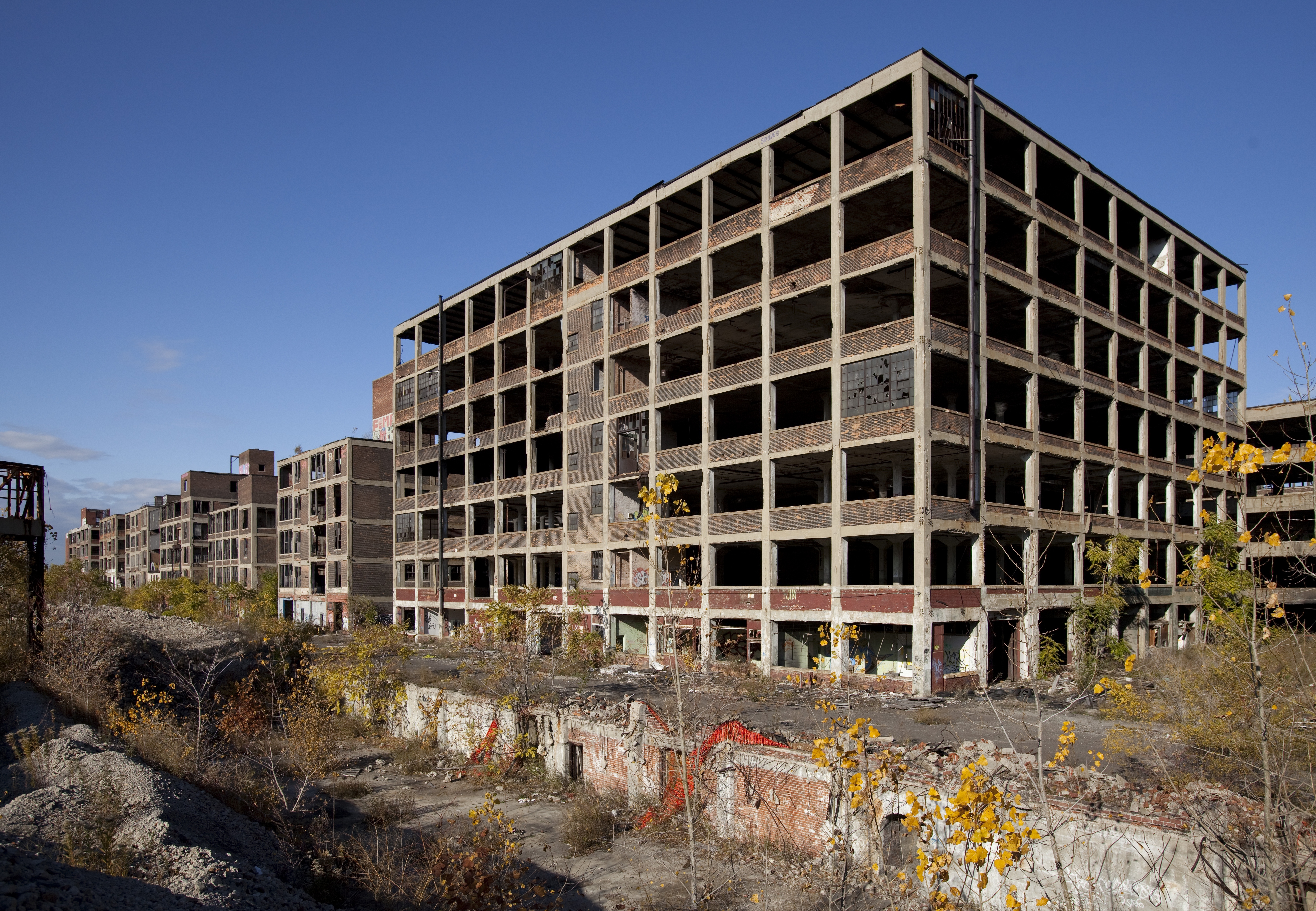
Abandoned Packard Automobile Factory Detroit. Source: https://commons.wikimedia.org/wiki/File:Abandoned_Packard_Automobile_Factory_Detroit_200.jpg User: Albert Duce. License: CC BY-SA 3.0

  •  Innovative and high tech industries have established technology parks and high-tech hubs located in the most economically important cities. Bring together high-tech industries that, this way, can find qualified workers, infraestructure support and advanced services.
  • Other traditional industries has been relocated to the outskirts of cities or rural regions and have established industrial parks.
  • In newly industrial countries, has been established industrial complexes near ports.


8. INDUSTRY AND GLOBALISATION. TYPES OF LOCATION AND RELATED FACTORS.

8. 1. Types of contemporary industry.

We can classify contemporary industries according to several criteria:
  • Position in the production process:
  1. Heavy industry produces semifinished products,
  2. Capital goods industry transforms semi-finished products into equipment needed by other industries.
  3. Consumer goods industry manufactures products inteded directly for consumers.
  • Weight of the raw materials:
  1. Heavy industry
  2. Semi-heavy
  3. Light industry, use lightweight materials.
  • Size. Can be:
  1. small (less than 50 workers).
  2. medium-size (between 50 and 250)
  3. large size (more than 250).

 8. 2. Contemporary factors of industrial location.

Economic globalisation has established an international division of industrial work:
  • High-tech industries are located in the most developed countries, because they need:
  1. advanced services and infraestructure.
  2. a qualified labour force.
  3. A large number of consumers with a higher purchasing power.
  • Mature or low-technology industries, located in emerging or undeveloped countries, due to:
  1. An abundant, but relatively unqualified and low-cost labour force.
  2. State concessions such as duty-free zones and permissive enviromental legislation.

9. THE WORLD'S INDUSTRIAL AREAS.

Today, we can distinguish three industrial ares in the world:

  • The historical industrial areas: United States, Japan and the European Union, with the following characteristics:
  1. Use of advanced technologies.
  2. High spending power of their markets
  3. The headquaters of most of the biggest world's companies are located there.
  4. Industry in decline, as a consequence of the offshoring of basic industies and a part of the consumer goods and equipment industies to emerging counties.
  • Emerging countries including the BRICS and some regional industrial powers. This countries has started a highly developed and growing industrialisation process:
  1. Explotation of abundant natural resources.
  2. Globalisation. The prodution of the cheap low and medium-tech products has been moved to these countries to take advantage of their cheap labour force. Lates these countries have used the capital and technology adquired to set up high-tech industries.
  • The least industralised areas, such as Sub-Saharan Africa, because of:
  1. Lack or resources and capital.
  2. Limited markets.
  3. Poor comunications.


domingo, 26 de noviembre de 2017

UNIDAD 3. LA HIDROSFERA.

1. EL AGUA EN LA NATURALEZA.

La presencia de agua permite la presencia del hombre, su asentamiento y la aparición de actividades económicas.

La hidrosfera.

Hidrosfera es el conjunto de aguas que hay en la Tierra. De ella forman parte:
  • océanos y mares.
  • ríos.
  • lagos.
  • casquetes polares y glaciares.
  • aguas subterráneas (acuíferos).
  • vapor de agua atmosférico.
Dos terceras partes de la superficie terrestre está cubierta por agua.

El ciclo del agua.

El ciclo natural de agua es el proceso circulatorio por el que el agua está cambiando continuamente de estado (solido, liquido o gaseoso).
El ciclo del agua explica el origen de las aguas continentales, tanto superficiales como subterráneas.
En el ciclo del agua podemos distinguir las siguientes fases:
  1. Evaporación: el calor del Sol evapora el agua del mar y de los océanos. 
  2. Condensación: el vapor de agua se enfría y se condensa, formando nubes. El viento arrastra las nubes sobre los continentes.
  3. Precipitación: al ascender el vapor de agua se condensa y parte del mismo se precipita en forma de lluvia, nieve o granizo.
  4. Infiltración: parte del agua se infiltra en el suelo, pasando a formar parte de las aguas subterráneas.
  5.  Escorrentía: otra parte del agua discurre en forma de ríos.
  6. La mayor parte del agua vuelve al mar al desembocar los ríos.
El ciclo del agua permite que la cantidad de agua presente en el planeta se mantenga constante.

El ciclo del agua.

El agua, como fuente de recursos.

Podemos dividir el agua de la Tierra en aguas oceánicas (mares y océanos) y aguas continentales (ríos y lagos, glaciares, aguas subterráneas. Las aguas oceánicas se caracterizan por ser agua salada y constituyen un 97% del total, mientras las aguas continentales son aguas dulces y suponen solo un 2%.

El agua dulce se distribuye de la siguiente manera:
  • 70% en los glaciares.
  • 29,6% en aguas subterráneas.
  • 0,4% en lagos y ríos.
El agua dulce es un recurso escaso y repartido de forma desigual, lo que ha causado conflictos y fuertes desigualdades que no dejan de aumentar.

El agua en el mundo.

 2. LAS AGUAS OCEÁNICAS.


Océanos, son las grandes masas de agua que separan los continentes.

Océano Atlántico.

Mares, las zonas de los océanos que se encuentran más próximas a los continentes.

Mar Báltico.

Agua salada.

Aproximadamente un 71%, o casi tres cuartas partes de la superficie terrestre está cubierto por océanos o mares, que suponen un 97% del total del agua del planeta.
La principal característica de las aguas marinas es que son saladas. La salinidad es consecuencia de la disolución de las rocas que los ríos transportan hasta los océanos.
El cloruro sódico (sal de mesa) constituye un 80% de las sales minerales que se encuentra en los océanos.
La salinidad de los mares depende de dos factores:
  • la temperatura. Los mares situados en latitudes cálidas, presentan una salinidad mucho mayor, debido a la mayor evaporación.
  • los mares cerrados. En las cuencas cerradas la evaporación es mayor, lo que hace aumente la salinidad. Por ejemplo, en el Mar Rojo la salinidad es ocho veces mayor que en el Báltico.

Agua en movimiento

La segunda característica es que el agua marina está en constante movimiento. Podemos distinguir tres tipos de movimientos del agua de mar:
  • las olas son ondulaciones de la superficie del agua provocadas por el viento. El agua se riza, empujando a las que tiene a su alrededor, y así sucesivamente, provocando un movimiento circular. 
  • las mareas son subidas y bajadas del nivel del mar provocadas por la fuerza gravitatoria de la Luna. Cuando el nivel del mar sube, hablamos de marea alta, y cuando baja, de marea baja.
  • las corrientes marinas son movimientos de grandes masas de agua que discurren por los océanos. 
  1. La causa de las corrientes son las diferencias de temperatura y nivel de salinidad de las aguas de la corriente y las aguas que la rodean.
  2. Cuando el agua de la corriente está más caliente que la que está a su alrededor, es una corriente fría. Cuando el agua de la corriente está más fría, hablamos de corriente fría.

Las corrientes marinas.

Aprovechamiento de las aguas oceánicas.

El ser humano siempre ha intentado aprovechar las aguas oceánicas. Las principales formas de explotación son:
  1. Alimentación: pesca, acuicultura (cría de especies acuáticas) y piscicultura (cría de peces).
  2. Fuente de energía: yacimientos petrolíferos, gas y aprovechamiento de la fuerza de las mareas.
  3. Transporte. Desde la antigüedad, los océanos y mares han sido una de las principales vías de transporte de personas y mercancías.
  4. Turismo, las costas son uno de los principales destinos turísticos, generando una gran cantidad de puesto de trabajo.
  5. Agua potable, mediante la desalinización del agua de mar.


3. LAS AGUAS CONTINENTALES.

Solo el 2, 79% del agua de la Tierra es agua dulce. De esta, el 70% corresponde a los icebergs y glaciares; el 29,6% a aguas subterráneas; y solo un 0,4% a los ríos y lagos.

Los ríos y los lagos.

  • Los ríos son corrientes continuas de agua. Se alimentan de:
  1. agua de lluvia.
  2. manantiales.
  3. nieve fundida.
Tenemos que distinguir ente:
  1. el caudal, la cantidad de agua que lleva el río.
  2. el régimen de un río, los cambios del caudal del río a lo largo del año.
Río.

  • Los lagos son masas de agua permanentes depositadas en depresiones. Se alimentan de:
  1. agua de lluvia
  2. agua de ríos y acuíferos.
Lago.

Las aguas subterráneas.

Las aguas subterránea son las que se encuentran bajo la superficie terrestre. Reciben el nombre de acuíferos.
Se alimentan del agua de la lluvia que se infiltra en el suelo hasta encontrar rocas impermeables y acumularse.
Los acuíferos tienen una importancia fundamental debido a:
  • aportan una gran parte de su caudal a los ríos y lagos.
  • son una reserva importante de agua dulce.
Son muy vulnerables a a la contaminación y la explotación.

Los icebergs y glaciares.

Criosfera es el conjunto de masas de agua helada. Está formada por:
  1. los glaciares.
  2. los casquetes polares.
Glaciar, masa de agua helada formada por la acumulación de nieve.

Agua atmosférica.

En la parte baja de la atmósfera, la troposfera, se encuentra agua en estado gaseoso (vapor de agua). 

Nubes.

Usos de las aguas continentales.

El agua dulce de los lagos y ríos es fundamental tiene multitud de usos:
  • Consumo humano: beber, lavarse, etc.
  • La agricultura, consume un 80% del agua disponible.
  • La industria, el agua es esencial para la producción.
  • Producción de energía hidroeléctrica.
  • Turismo atraído por la belleza del paisaje y actividades deportivas.
El agua es fundamental para la vida humana como demuestra está imagen de Oriente Próximo de noche. Como podéis ver, la mayor parte de la población del este de Siria se concentra en los valles de los ríos Eufrates y Jabur, mientras que en desierto que los rodea apenas hay población.


 4. LA DISTRIBUCIÓN DE LAS AGUAS DEL PLANETA.


Podemos dividir las aguas del planeta en cinco grandes océanos que separan los continentes y grandes archipiélagos:

  • El océano Pacífico se encuentra situado entre Asia, América y Oceanía. En el se encuentran centenares de archipiélagos e islas volcánicas.


  • El océano Atlántico situado entre América, Europa y África. Se caracteriza por: 
  1. su escasa profundidad.
  2. la presencia de mares costeros como el Mar Caribe, el Cantábrico y el de Norte.


  • El Océano Índico situado entre Asia y África. Se caracteriza por:
  1. Existen pocas islas.
  2. Destaca el Mar Arábigo y el golfo de Bengala.
  • El Océano Glacial Ártico y el Océano Glacial Antártico, se caracterizan por:
  1. se encuentran en las zonas que rodean los polos.
  2. una parte de sus aguas se encuentran heladas de forma permanente.
En cuanto a las aguas continentales, constituidas principalmente por ríos y lagos podemos dividirlas según los continentes:
  • La Antártida se encuentra cubierta por una gruesa capa de hielo. Contiene un 90% de las aguas del planeta.
  • En Asia podemos distinguir entre:
  1. Los ríos mas importantes son: el Obi, el Yenisei, el Lena, el Amur, el Huang He, el Chiang Jiang, el Mekong, el Ganges y el Indo.
  2. Entre los lagos: el Mar Caspio (el lago más grande la Tierra) y el Baikal.


Los ríos de Asia.


    • En África podemos distinguir:
    1. Los principales ríos: el Nilo, el Niger, el Congo, el Zambeze, el Limpopo y el Orange.
    2. Los principales lagos son: el Victoria, el lago Chad y el Tanganyka.


    • En América podemos distinguir entre: 
    1. Los ríos más importante son: el Yukon, el Mackenzie, el San Lorenzo, el Missouri, el Mississip, el Orinoco, el Amazonas y el Paraná.
    2. Los lagos más importantes son los Grandes Lagos en Norteamérica y el Titicaca en Sudamérica.


    • En Oceanía destacan:
    1. Los ríos más importantes de Australia: el Darling y el Murray.
    2. El lago Eyre, un lago salado que solo se llena de agua durante ciertas momentos del año.

    El lago Eyre seco. File: LakeEyreSaltCrust.JPG User: Phanly CC BY 3.0


     Antártida.

    La Antártida está completamente cubierta por una capa de hielo de más de 2.000 metros de espesor.

    Montes Ellsworth, Antartida. El interior de la Antartida está completamente cubierto por una capa de hielo de más 2.000 metros de espesor y no hay agua liquida, lo que hace que no haya vegetación, y ni vida animal ni humana como consecuencia.


     TRABAJO.

    Como sabéis, la evaluación es el próximo lunes, días 18/12, pero algunos me habéis preguntado si existía la posibilidad de subir nota, haciendo algún trabajo. He pensado, que podríais hacer un trabajo referido a alguno de los ríos más importantes del mundo: el Nilo o el Amazonas. La fecha limite para enviármelo sería este domingo, porque la evaluación es el lunes. Podríais enviarlo a esta dirección de correo electrónico: afernndelpz@gmail.com. Se trata de que busquéis información sobre ellos para responder a las siguientes preguntas:

    -¿Qué longitud tiene? ¿Donde nace? ¿Tiene afluentes? ¿Que países recorre? ¿En que océano o lago desemboca?

    -¿Se hiela en invierno? ¿Qué climas tienen las zonas que atraviesa? ¿Qué tipo de fauna y vegetación se encuentra en su cuenca?

    -Ha sido importante para el desarrollo de alguna civilización? ¿Es importante para la economía de los países por los que pasa? ¿Por qué?

    NILO:

    http://www.egipto.com/el_nilo/

    http://www.egipto.com/egipto_para_nino/el_nilo.html

    http://webdehistoria.blogspot.com.es/2009/08/el-rio-nilo.html

    http://www.geoenciclopedia.com/rio-nilo/

    AMAZONAS:

    http://www.geoenciclopedia.com/rio-amazonas/

    https://historiaybiografias.com/amazonas/

    http://www.monografias.com/trabajos32/amazonas/amazonas.shtml

     https://www.ecured.cu/Amazonas_(r%C3%ADo)


    ACTIVIDADES.

    1.  JUEGO DE REPASO.


    2. IDENTIFICA LAS SIGUIENTES FORMAS DEL RELIEVE DE AMÉRICA.


    SOLUCIONES.

      1. JUEGO DE REPASO.


     2. IDENTIFICAR LAS SIGUIENTES FORMAS DEL RELIEVE DE AMÉRICA.


    Los ríos de Europa.

    domingo, 19 de noviembre de 2017

    UNIT 3. THE HYDROSPHERE.

    WATER IN THE OCEANS.

    We have to distinguish between the concepts of ocean and sea:

    • ocean, a body of water that separates the continents.
    • sea, an extension of one ocean, usually close to the coast.
    Atlantic Ocean.

    Mediterranean Sea.

      1. 1. Oceans waters.

    Oceans covers around a 71% of the Earth's surface and oceanic waters suppose about a 97% of the Earth's water. These waters are salines waters because the rivers carry rocks and salts to the sea.
    Its salinity depends of two factors:
    • Water in landlock seas are saltier.
    • Water in warmer latitudes because the heat causes more evaporation. 

     1. 2. Water in movement.

    Seawater is constantly moving. There are three types of movements of oceanic waters:
    • Waves, is the up and down movement of the surface of the ocean caused by the wind. 
    • Tides, are the rising and falling of the sea level caused by gravitational pull of the Moon. When the sea level rises, it is high rise, when the sea level is low, it is low tide.
    • Ocean currents are like big rivers moving within the oceans. It causes is the differences of salinity and temperature between the different parts of the ocean. Can be:
    1. Cold when the water inside the current is colder than the water around it.
    2. Warm, when the water is warmer.


    3. FRESH WATER.

    Less than 3% of the water on Earth is fresh water. Of this three percent, around a 70% is located in glaciers, 29'6% is located is groundwater and only a 0'4% is found in rivers and lakes.

    3. 1. River and lakes.

    • A river is a flowing stream of water.
    • Flow is the amount of water that a river carries.
    • The flow regime are the changes in the flow of the river during the year.
     We can distinguish three parts in the course of a river:
    1. Upper course, the river flows in the mountains. Here flows very fast.
    2. Middle course, the river flows through flat lands. The speed of the current is slower and the current of the river bends, forming meanders. A meander, is a bend in the course of the river formed by the accumulation of sediments.
    3. Lower course, the river flows into the sea.
    Upper course.

    Middle source.
    Lower course

    • Lakes are permanent bodies of water. Its water comes from rainfall, rivers and groundwater.

    Groundwater.

    Groundwater is water that flows under the surface.
    Aquifers are underground rivers. Its water comes from rainfall and them feed the rivers.
    Aquifers are vulnerable to pollution and overuse.

    Icebergs and glaciers.

    Most of the freshwater on Earth is frozen.
    Criosphere includes all the ice in the world: ice caps and glaciers.
    • Glaciers, large acumulation of frozen water.  Them have two main parts:
    1. Cirque, a steep bowl-shaped depression which form the head of the glacier.
    2. Tongue, a narrow extension of ice projecting from the glacier cirque.


    Water in the atmosphere.

    Most of the water in the atmosphere is found is its lower part, the troposphere.

    Use of water.

    The main uses of water are:
    • Domestic consumption.
    • Agriculture, an 80% of the water is used in it.
    • Urban underground deposits for cleaning and irrigation services.
    • Energy production.
    • Tourism.

    4. THE DISTRIBUTION OF WATER ON OUR PLANET.

    Earth has five oceans divided by the continents and rivers and lakes are found on the different continents.

    4. 1. Oceans.

     
    World's oceans. File: Los océanos. http://recursostic.educacion.es/bancoimagenes/web/ Author:        José Alberto Bermúdez. License: CC BY-NC-SA 3.0

    •  The Atlantic Ocean is the shallowest and has many seas such as the Mediterranean and the Bay of Biscay.
    • The Pacific Ocean contains hundreds or archipielagos and experiences frequent volcanic eruptions.
    •  The Indian Ocean.

    File:Indian Ocean laea relief location map.jpg https://commons.wikimedia.org/wiki/File:Indian_Ocean_laea_relief_location_map.jpg https://commons.wikimedia.org/wiki/User:Uwe_Dedering
    CC BY-SA 3.0
    •  Antartic and Artic Oceans surround the Earth's poles. 


    4. 2. Asian rivers and lakes.

    The most important rivers of Asia are:
    • siberian ribers: the Ob, the Yenisei and the Lena.
    • rivers that flow into the Pacific Ocean: the Amur, the Huang He, the Chang Jiang, the Mekong.
    • rivers that flow into the Indian Ocean: the Ganges and the Indus.
    The most important lakes are:
    • The Caspian Sea, the biggest lake on the world, the Aral Sea and the Lake Baikal (the deepest in the world). 
    The most important seas are:
    • the Arabian Sea and the Sea of Japan.


    Baikal Lake frozen.

    Road over the frozen Lena river. File: https://commons.wikimedia.org/wiki/File:Lena_River_Ice_Road.jpg Author: https://www.flickr.com/people/61591788@N00

    The Lena river during the summer. File: Lena River in Biakal-Lena Zapovednik Author:
    Яхин Василий  CC BY-SA 4.0
    The Huang-He's lower course. It is known also as the Yellow river due to the large amount of sediments and sand that the river carries. https://upload.wikimedia.org/wikipedia/commons/4/4f/Yellow_river_-_A._Holdrinet.jpg User: André Holdrinet. CC BY-SA 3.0


    4. 3. America.

    • The most important rivers are: the Yukon, the Mackenzie, the Mississippi-Missouri, the Río Grande, the Orinoco, the Amazon river (the river with the highest flow in the world) and the Paraná-Paraguay.
    • The most important islands are Greeenland and Cuba.


    4. 4. Africa.

    African rivers are very long and carry a high volume of water. The main rivers are: the Nile (the longest river in the world with 6.670 km), the Niger, the Congo, the Zambezi and Orange.

    There are several lakes of two types:
    • located in basins (Victoria, Chad).
    • located in fractures in the terrain (Albert, Tanganyka and Malawi).
    Victoria Falls, located in the Zambezi river.


    About the coast the main features are:
    • Islands: Madagascar.
    • Gulfs: Guinea.
    • Capes: Good Hope.

    Egypt as seen from space at night. More than a 90% of the population of Egypt lives along the Nile's river valley, because of this, Egypt has been called since ancient times "a gift from the Nile".


     4. 5. Oceania.

    The most important lake is Lake Eyre in Australia. It is salty.
    The most important rivers are the Darling and the Murray.
    The most important feature of the coastal relief is the Gulf of Carpentaria.


     4. 6. Antarctica.

    Antarctica is completely cover by a layer of ice 2.000 meters deep.


    5. RIVERS AND LAKES OF EUROPE.

    We can distinguish several hydrographic basins in Europe according to the ocean or sea in which the rivers flow into:
    • Artic rivers, such as the Dvina.
    • Atlantic rivers, such as the Elbe, the Rhine, the Thames, the Seine, the Loire, the Garonne and the Tagus.
    • Mediterranean rivers: the Rhone, the Tiber and the Po.
    • Black Sea rivers: the Danube, the Dnieper and the Don.
    • Caspian Sea rivers: the Ural and the Volga.


    ACTIVITIES.

    1. REVIEW GAME.


     2. HANGMAN.

    1. A long river located in North America. Its course join with the course of the Mississippi river.

    __  __  __  __  __  __  __  __.

    2. A river located in the Indochina Peninsula.
    __  __  __  __  __  __.

    3. An african lake located in a elongated depression.
    __  __  __  __  __  __  __  __  __.

    4. An australian lake. It is only fill with water when its rains.

    __  __  __  __.

    3. Fill the blank spaces. 

     4. WORLD'S OCEANS. Identify the names of the different oceans and the seas that appear in the map.


    SOLUTIONS.

    1. 


     2. HANGMAN.

    1. A long river located in North America. Its course join with the course of the Mississippi river.

    MISSOURI.

    2. A river located in the Indochina Peninsula.

    MEKONG

    3. An african lake located in a elongated depression.

    TANGANYKA.

    4. An australian lake. It is only fill with water when its rains.

    EYRE.

    3. Fill the blank spaces.


    4. OCEANS OF THE WORLD.