1. The Earth's outer layer.
The activity inside the Earth produces different types of relief.The Earth's structure.
We can divide the Earth in three large sections:- The core (in spanish núcleo) is the innermost part of the Earth and a 15% of its volume. We can distinguish between a solid inner core and a liquid outer core.
- The mantle (in spanish manto) that is located around the core (84% of the Earth's volume). It is made of molten rock or magma.
- The outer layer is the crust (in spanish corteza) (1% of the Earth's volume). Is made of solid rocks such as basalt or granite.
-
Lithosphere is the outer solid layer of the Earth, is made up of the crust and the upper part of the mantle.

The Earth's crust.
Its main characteristics are:- It is thicker in the continents and thinner in the oceans.
- It is not smooth, is covered by different features that make the Earth's relief (mountains, plateus, valleys).
- It is changing constantly due to the internal and external force of the Earth.
- It is divided into different pieces (tectonic plates) that rise or sink, due the pressure from the molten materials of the mantle.
Continental drift.
According to this theory, 200 million years ago, the continents were connected in a single landform, Pangea. but this continent broke up into fragments to make modern day continents.- The tectonic plantes are the large sections in which the Earth's crust is divided and they float over the mantle.
- Ocean ridges are large mountain ranges located between two large plates.
2. Internal forces and the formation of the relief.
The relief is form by the earth’s internal forces which
raise, sink or move blocks of terrain. The main internal forces are: volcanoes and earthquakes.
We can distinguish different parts:

- Volcanoes are ruptures in Earth’s crust through which magma are released onto Earth’s Surface. Are located in áreas where two tectonic plates make contact.
We can distinguish different parts:
- Crater, the opening through which the magma reach the Earth's surface.
- Vent, the crack that allow the magma to cross the crust.
- Cone, an acumulation of ashes, rocks and cooled magma around the crater of the volcano.

- Earthquakes (in spanish terremoto), sudden movements of the Earth’s crust caused by the clash of two tectonic plates. These movements travels in the form of seismic waves. We have to distinguish between:
- Epicentre. The point in the surface where the earthquake causes the most damage.
- Hypocentre. Origin of the earthquake.

3. Relief modification and its agents.
There are four external forces that explain the modification of the relief: water, wind, vegetation and human beigns.

3. 1. Water.
Water is the most important force of the modification of the relief and modify the relief in several ways:- Rainfall form rivers which erode mountains, excavate ravines and valleys and finally deposit the erorded materials, forming plains and deltas.
- Snow in the mountains acumulates forming glaciers which excavate glacial valleys.
- Ice. Rainfall penetrates cracks in rocks. When temperatures fall, become ice, its volume increase and the pressure break rocks apart.
- Chemical weathering. Water reacts with some components in rocks, dissolving them and forming cracks. Water can create caves and underground rivers.
- Ocean waters (waves, currents, tides) erodes coastlines and deposit sand, forming beaches and gulfs.


3. 2. Wind.
The wind erodes rocks and transports sand and dust. Wind erosion is greater in dry places with no vegetation.
3. 3. Vegetation.
Plant roots penetrate the ground, breaking rocks, but also prevent soil erosion by holding the soil in place.


3. 4. Human beigns.
Human activity changes the enviroment in several ways:- Construction of infraestructures: motorways, railways, bridges, dams, etc.
- Explotation of resources: mining, logging.
3. EARTH’S LANDFORMS.
3. 1. Continental relief.
We can find
four main landforms in the continental relief:
- Plains (in spanish llanura). A large open area of flat or slightly undulating terrain.
- Plateaus (in spanish meseta). A elevated large open area of land.
- Mountains (in spanish montaña). A large landform that is higher than the surrounding land and has very stepped sides.
- Basin or depression (in spanish depresión). An area of land lower than the surrounding area. Can be formed by: the erosive action of the rivers and shifting of tectonic plates.
- Valley, a long basin in the land. Can be:
-Glacial valley, caused by a moving glacier. Are U-shaped.
 |
| Plain. |
 |
| Plateau. |
 |
| Mountain. |
 |
| Depression. Mountain valley. |

4. 2. Ocean relief.
The main
landforms of the oceanic relief are:
- Continental shelf. The undersea extensión of the continents that descend gradually
- Continental slope: a steep underwater área that links the continental shelf with the abyssal plains.
- Abyssal plain. A flat area of ocean floor with a depth of between 3.000 and 7.000 metres.
- Oceanic ridge. A large underwater mountain range.
- Oceanic trench. A long basin located in the abyssal plains which reaches depths of between 6.000 and 11.000 metres.

4. 3. Coastal relief.
The main
landforms or the coastal relief are:
- Beaches: flat surfaces found along the sea shore, are formed by the acumulation of sediments.
- Cliffs: elevated areas with a very steep side located on a coast.
- Capes or headlands (in spanish cabo), areas where the coast juts into the sea or land surfaces that are partially surrounded by the sea.
- Gulfs (in spanish golfo), areas where the sea is partially enclosed by the Earth.
- Inlet (in spanish ría), river valleys which have been flooded by the sea.
- Fjord (in spanish fiordo), a glacial valley which have been flooded by the sea.
- Delta (in spanish delta) a coastal landform located at the mounth of a river, formed by the accumulation of sediments.
- Peninsula (in spanish peninsula), extension of land surrounded by water on all sides except one.
- Ithsmus (in spanish itsmo), is the extension of land which links the peninsula to the continent.
 |
| Sandy beach, |
 |
| Cliff. |
 |
| Cape or headland. |
 |
| Gulf of Naples. |
 |
| Rio de la Plata's estuary diagram. |
 |
| Fjord, Norway. |
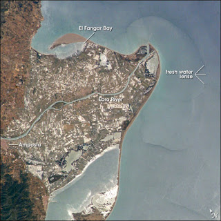 |
| Ebro's delta. |
 |
| Peninsula. |
 |
| Ithmus. |

5. THE EARTH'S RELIEF.
5. 1. Africa.
Africa is quite flat and most of it is covered by plateaus and basins that contain great rivers and lakes. The main landforms are:- old massifs (old mountain ranges): Ahaggar, Tibesti, Darfur.
- young mountain ranges: Atlas, Drakensberg.
- Basins occupied by big rivers and lakes: Niger, Chad, Nilo, Congo y Zambeze.
- The Great Rift Valley a huge fracture located between two tectonic plates. In it are located several volcanoes such as the Mount Kenia and the Kilimanjaro.

 |
| Ahaggar mountains. |
 |
| Drakensberg mountains. |
 |
| Rift Valley. |
 |
| Mount Kilimanjaro. |
5. 2. Asia.
The main landforms of the asian relief are:
- In the north a series of huge plains and plateaus, such as the Western Siberian Plain and the Cental Siberian Plateau.
- In the center a series of big plateaus and mountain ranges: Pamir Plateau, Tibet Plateau, Iranian Plateau, Zagros Mountains and the Himalayas.
- In the south a series of big penínsulas and archipiélagos: Arabian Peninsula, Indochinese Peninsula, Korean Peninsula, Japanese Archipielago, the Philippines Archipielago, etc.

 |
| Putorana plateuau. Olga Chuma CC BY-SA 3.0 |

 |
| Japanese archipielago. |
 |
| Tibetan Plateau. |
5. 3. America.
The Americas are located between the Pacific and Atlantic Oceans. Is divided between North and South America which are connected by the isthmus of Panama. The main landforms area:- In the west a long series of young mountain ranges that goes from Alaska to Tierra de Fuego: the Rocky Mountains, the Sierra Madre and the Andes. In the Andes is located the Aconcagua, the highest mountain of the continent.
- In the centre, a series of plains and rive basins in which appear the longest rivers of the continent: the Great Plains, the Amazon Basin, the Pampas.
- In the east, a series of old massifs with rounded peaks and no higher than 3.000 metres, such as the Appalachians, the Guiana Shield and the Brazilian Highlands.

 |
| Rocky mountains. Canada. |
5. 4. Australia/Oceania.
Oceania is located between the Indian and the Pacific Oceans and includes more than 10.000 islands located in the South Pacific and divided into four main archipielagos: Australasia, Melanesia, Micronesia and Polynesia.The main landforms are:
- In Australia, the Great Dividing Range, the Nullarbor Plain and the Great Artesian Basin.
- In New Zealand, the Southern Alps.


 |
| Blue Mountains. Great DIviding Range. CC0. |
 |
| Nullarbor plain from space. |
6. THE EUROPEAN RELIEF.
Europe is a small continent (less than a 5% of Earth's surface), limited by:- In the north and the west the Antarctic and Atlantic Oceans.
- In the South the Mediterranean Sea.
- The Great European Plain:
- It extends across most of the continent.
It is relatively narrow in the west (Belgium), but wider in the east, covering most of European Russia.
It is crossed by great rivers: the Rhine, Vistula, Volga, Don, Dnieper.
- The plateaus and old mountain ranges. Old massifs that are low and smooth due to erosion.
The most important are:
- the Scandinavian Mountains (Scandinavian Peninsula)
- the Grampian Mountains (North of Great Britain).
- the Spain's Meseta (Iberian Peninsula)
- the French Massif Central (center and south of France)
- the Ural Mountains (Russia).
- The young mountain ranges.
A series of young and high mountain ranges located in the south of Europe:
- The Pyrenees, located between the Mediterranean Sea and the Bay of Biscay.
- The Alps , located between the Mediterranean and the Aegean Sea. The peaks are higher in the western sector.
- The Apeninnes, that cross the Italian Peninsula from North to South.
- The Carpathians, located in Easten Europe.
- The Balkans, in the Balkan Peninsula.
- The Caucasus, located between the Blak and Caspian Seas.


Tatra mountains, a part of the Carpathian mountains.

Mont-blanc.

Caucasus.
- the Scandinavian Mountains (Scandinavian Peninsula)
- the Grampian Mountains (North of Great Britain).
- the Spain's Meseta (Iberian Peninsula)
- the French Massif Central (center and south of France)
- the Ural Mountains (Russia).
- The young mountain ranges.
A series of young and high mountain ranges located in the south of Europe:
- The Pyrenees, located between the Mediterranean Sea and the Bay of Biscay.
- The Alps , located between the Mediterranean and the Aegean Sea. The peaks are higher in the western sector.
- The Apeninnes, that cross the Italian Peninsula from North to South.
- The Carpathians, located in Easten Europe.
- The Balkans, in the Balkan Peninsula.
- The Caucasus, located between the Blak and Caspian Seas.

 |
| Tatra mountains, a part of the Carpathian mountains. |
 |
| Mont-blanc. |
 |
| Caucasus. |
ACTIVITIES.
1.EARTH'S LANDFORMS.
UNIT
1. THE RELIEF.
With an A
|
Huge extensións of
flat terrain located between the continental shelfs with a depth of between
4. 000
and 5.
|
|
Contains a B
|
Flat surfaces found
along the sea shore, are formed by the acumulation of sediments.
|
|
With a C
|
An area where the
coast juts into the sea or land surfaces that are partially surrounded by the
sea.
|
|
With a C
|
elevated areas with
a very steep side located on a coast.
|
|
With a C
|
The exterior layer
of the Earth, is made up of solid rock.
|
|
With a D
|
A coastal landform
located at the mounth of a river, formed by the accumulation of sediments.
|
|
With an E
|
Sudden movements of
the Earth’s crust caused by the clash of two tectonic plates.
|
|
Contains an F
|
A glacial valley
which have been flooded by the sea.
|
|
With a G
|
Areas where the sea
is partially enclosed by the Earth
| |
With a E
|
River valleys which
have been flooded by the sea.
|
|
With a H
|
Consists of all the water in the surface of the Earth.
|
|
Contains an I
|
Is the extension of
land which links the peninsula to the continent.
|
|
With an L
|
The outer solid layer of
the Earth, is made up of the crust and the upper part of the mantle.
|
|
With an L
|
A depression filled
by water
|
|
With a M
|
Elevated landforms
which have an altitude of more tan
|
Mountain
|
With an M
|
Old mountains which
have rounded forms.
|
Massif
|
Contains a N
|
A gentle slope
that
extends
from
the
continents
beneath
the
sea waters.
|
Continental shelf
|
With a P
|
extension of land surrounded by water on all sides except one.
|
Peninsula
|
With a P
|
Extensive áreas of flat or gently undulating land which are located at
an altitude of less than
|
Plain
|
With a P
|
Elevated plains which are located at altitudes of more tan
|
Plateau
|
With an R
|
Large group of
mountains.
|
|
With an R
|
Underwater
mountains systems of several thousands metres of height.
|
Oceanic Ridge
|
With a T
|
Narrow elongated
drepressions which cut the abyssal plains
|
|
With a T
|
Huge wave that
appear as a consequence of a underwater earthquake.
|
|
With a S
|
Sharp decline
between the continental shelf and the abyssal plain.
|
Continental Slope
|
With a V
|
Sunken area of
terrain located between mountains or plateaus
|
Valley
|
With a V
|
ruptures in Earth’s
crust through which magma are released onto Earth’s Surface
|
Volcano
|
UNIT
1. THE RELIEF.
With an A
|
Huge extensións of
flat terrain located between the continental shelfs with a depth of between
4. 000
and 5. 000 metres.
|
Abyssal plain
|
Contains a B
|
Flat surfaces found
along the sea shore, are formed by the acumulation of sediments.
|
Beach
|
With a C
|
An area where the
coast juts into the sea or land surfaces that are partially surrounded by the
sea.
|
Cape
|
With a C
|
elevated areas with
a very steep side located on a coast.
|
Cliff
|
With a C
|
The exterior layer
of the Earth, is made up of solid rock.
|
Crust
|
With a D
|
A coastal landform
located at the mounth of a river, formed by the accumulation of sediments.
|
Delta
|
With an E
|
Sudden movements of
the Earth’s crust caused by the clash of two tectonic plates.
|
Earthquake
|
Contains an F
|
A glacial valley
which have been flooded by the sea.
|
Fjord
|
With a G
|
Areas where the sea
is partially enclosed by the Earth
|
Gulf
|
With a E
|
River valleys which
have been flooded by the sea.
|
Estuary.
|
With a H
|
Consists of all the water in the surface of the Earth.
|
Hidrosphere
|
Contains an I
|
Is the extension of
land which links the peninsula to the continent.
|
Ithsmus
|
With an L
|
The outer solid layer of
the Earth, is made up of the crust and the upper part of the mantle.
|
Litosphere
|
With an L
|
A depression filled
by water
|
Lake
|
With a M
|
Elevated landforms
which have an altitude of more tan 600 metres and very steep slopes.
|
Mountain
|
With an M
|
Old mountains which
have rounded forms.
|
Massif
|
Contains a N
|
A gentle slope
that
extends
from
the
continents
beneath
the
sea waters.
|
Continental shelf
|
With an O
|
The process that
explain the apparition of mountains. It occurs in the area where two tectonic
plates come into contact.
|
Orogenesis
|
With a P
|
extension of land surrounded by water on all sides except one.
|
Peninsula
|
With a P
|
Extensive áreas of flat or gently undulating land which are located at
an altitude of less than 200
metres above sea level.
|
Plain
|
With a P
|
Elevated plains which are located at altitudes of more tan 200 metres above sea
level.
|
Plateau
|
With an R
|
Large group of
mountains.
|
Mountain Range
|
With an R
|
Underwater
mountains systems of several thousands metres of height.
|
Oceanic Ridge
|
With a T
|
Narrow elongated
drepressions which cut the abyssal plains
|
Oceanic Trench
|
With a T
|
Huge wave that
appear as a consequence of a underwater earthquake.
|
Tsunami
|
With a S
|
Sharp decline
between the continental shelf and the abyssal plain.
|
Continental Slope
|
With a V
|
Sunken area of
terrain located between mountains or plateaus
|
Valley
|
With a V
|
ruptures in Earth’s
crust through which magma are released onto Earth’s Surface
|
Volcano
|
2. HANGMAN.
And old massif located in Africa.__ __ __ __ __ __ __
__ __ __ __ __ __ __ __ __
The highest peak of Africa.
__ __ __ __ __ __ __ __ __ __ __.
A young mountain range located in North America.
__ __ __ __ __ __ __ __ __ __ __ __ __ __.
A plateau located in the center of Asia.
__ __ __ __ __ __ __ __ __ __ __ __ __ __.
2. HANGMAN.
And old massif located in Africa.TIBESTI MOUNTAINS.
The highest peak of Africa.
KILIMANJARO.
A young mountain range located in North America.
ROCKY MOUNTAINS.
A plateau located in the center of Asia.
TIBETAN PLATEAU.
3. Asian map. Identify the landforms that are identified with numbers in the map.

3. Asian map. Solution.
1. Central siberian plateau.
2. Arabian Peninsula.
3. Pamir plateau.
4. Plateau of Tibet.
5. Himalaya.
6. Korean Peninsula.
No hay comentarios:
Publicar un comentario