Etiquetas

1ºBACHILLERATO (2) 1ºBACHILLERATO PENDIENTES (6) 1ºESO (111) 1ºESO GEOGRAFÍA GEOGRAPHY RECUPERACIÓN (1) 2018-2019 (2) 2ºESO (1) 3ºESO (31) 4ºESO (13) 4ºESO UNIDAD 2. LAS REVOLUCIONES LIBERALES UNIDAD 3. LA REVOLUCIÓN INDUSTRIAL. HISTORIA (1) ACTIVIDADES (1) ADAPTACIÓN CURRICULAR (3) ADAPTACIÓN CURRICULAR. (2) ANCIENT (1) ANCIENT EGYPT (1) ANCIENT GREECE (2) BILINGUAL (57) BYZANTIUM (1) CHARLEMAGNE (1) EGIPTO (3) Geografía (39) GEOGRAPHY (35) GRECÍA (1) GREECE (2) HISTORIA (54) HISTORIA MODERNA (1) HISTORIA. UNIDAD 8. MESOPOTAMIA. (1) HISTORY (24) HISTORY UNIT 7 PREHISTORY (1) IBERIAN PENINSULA (1) LA GANADERIA (2) LA PESCA Y LA SILVICULTURA. (1) MANUEL DE FALLA (5) MESOPOTAMIA (4) PENDIENTES (1) PREHISTORIA (2) PREHISTORY (1) RECUPERACIÓN (3) RESUMEN. (1) ROMA (2) ROME (2) TALLER DE AMPLIACIÓN. (1) TEMA 5. EL IMPERIALISMO Y LA PRIMERA GUERRA MUNDIAL. (1) THE EARTH'S BIOCLIMATES (1) UNIDAD 1. EL SIGLO XVIII (2) UNIDAD 10. EL RENACIMIENTO (4) UNIDAD 10. LA ANTIGUA GRECIA (2) UNIDAD 10. LAS PRIMERAS CIVILIZACIONES (2) UNIDAD 10. LAS PRIMERAS CIVILIZACIONES: MESOPOTAMIA Y EGIPTO. (4) UNIDAD 10. LAS PRIMERAS CIVILIZACIONES. (1) UNIDAD 11. ANTIGUA GRECIA. (1) UNIDAD 11. LA CIVILIZACIÓN GRIEGA. (1) UNIDAD 11. ROMA. (2) UNIDAD 12. COLONIZACIONES Y PUEBLO PRERROMANOS (1) UNIDAD 12. EL AUGE DEL IMPERIO DE LOS AUSTRIAS. (2) UNIDAD 2. EL RELIEVE DE LA TIERRA. (7) UNIDAD 2. LA ORGANIZACIÓN ECONÓMICA DE LAS SOCIEDADES. (7) UNIDAD 2. LAS REVOLUCIONES LIBERALES (1) UNIDAD 2. LAS REVOLUCIONES LIBERALES. (2) UNIDAD 3. EL RELIEVE DE LOS CONTINENTES (1) UNIDAD 3. LA AGRICULTURA (7) UNIDAD 3. LA HIDROSFERA: AGUA DULCE Y AGUA SALADA (4) UNIDAD 3. LA REVOLUCIÓN INDUSTRIAL (1) UNIDAD 4. ESPAÑA EN EL SIGLO XIX. (1) UNIDAD 4. LA ATMÓSFERA (1) UNIDAD 4. LA ATMÓSFERA. (4) UNIDAD 4. LA ESPAÑA DEL SIGLO XIX (1) UNIDAD 5. LOS CLIMAS DE LA TIERRA. (1) UNIDAD 6. EL MUNDO DE ENTREGUERRAS. (1) UNIDAD 9. EGIPTO (2) UNIDAD 9. EL NACIMIENTO DEL MUNDO MODERNO. (5) UNIDAD 9. LA PREHISTORIA (1) UNIDAD 9. LA PREHISTORIA. (4) UNIDAD. 4 LA REVOLUCIÓN INDUSTRIAL. (1) UNIT 1. THE EARTH (1) UNIT 1. THE EARTH. (6) UNIT 1. THE FRAGMENTATION OF THE ANCIENT WORLD (1) UNIT 1. THE START OF THE MODERN AGE. (1) UNIT 10. THE FIRST CIVILIZATIONS. (2) UNIT 12. ANCIENT ROME (1) UNIT 2. THE EARLY MODERN AGE IN SPAIN AND AMERICA. (1) UNIT 2. THE EARTH'S RELIEF. (1) UNIT 2. THE EARTH'S SURFACE. (4) UNIT 2. THE PRIMARY SECTOR (1) UNIT 3. THE 17th CENTURY IN EUROPE. (1) UNIT 3. THE EARTH'S PHYSICAL CHARACTERISTICS. (7) UNIT 3. THE HYDROSPHERE. (1) UNIT 3. THE TERTIARY SECTOR. SPACE AND ACTIVITIES. (1) UNIT 4. THE ATMOSPHERE (2) UNIT 4. THE ATMOSPHERE. (1) UNIT 4. THE CLIMATE AND BIOCLIMATIC ZONES. (6) UNIT 5. THE EARTH'S BIOCLIMATES. GEOGRAPHY (1) UNIT 5. THE EARTH'S MAJOR BIOCLIMATIC ZONES. (3) UNIT 6. SPAIN'S PHYSICAL ENVIROMENT AND BIOCLIMATES. (1) UNIT 7. PREHISTORY (1) UNIT 7. PREHISTORY. (8) UNIT 8. THE FIRST CIVILIZATIONS. (2) UNIT 9. ANCIENT EGYPT (1) VISIGOTHS (1)

miércoles, 2 de noviembre de 2016

REPRESENTING THE EARTH: maps and systems of projection.

It is imposible to translate a sphere into a flat surface without change it, the same way that is impossible to flatten the skin of an orange without breaking it, because a flat surface and an sphere have different characteristics.
For exmple, in a flat surface the sum of the angles of a triangle always sums 180º, but in a sphere always sums MORE than 180º.
Because of this a map never is going to be a perfect representation of the Earth's surface.

Maps and their elements.
A map is a simplified representation of the Earth's spherical surface, or a part of it, depicted on a flat surface. 

In order to make a map, cartographers need three elements:a system of projection, a scale and set of standard sings or legend.

System of projection.

-A system of projection is a system that allow us to represent a spherical surface on a flat surface, translating the network of parallels and meridians.There are three main types of systems of projection:

  • cylindrical projection, transfers the grid of parallels and meridians into a cylinder. It is the best method to represent the low latitudes the low latitudes between the Equator and the tropics.
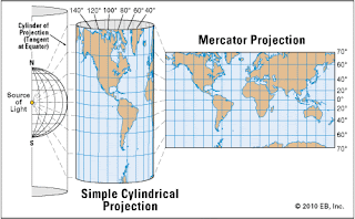
  • Conic or conical projection, transfer the grid of parallels and meridians into a cone. It is the best method to represent the mid-latitudes.
  • Azimuthal or plane projection, transfers the grid of parallels and meridians into a flat surface. It is the most appropiate method to represent the polar areas.
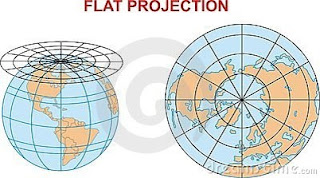

-Scale is the method that we use to indicate the relation between a distance drawn on the map and the same distance on the ground. There are two types of scale:

  • Numerical scale. It is indicates the relationship between the unit used to make the map and the reality. Usually a fraction is used. the numerator indicates the distance on the map and the denominator its equivalent on the ground.
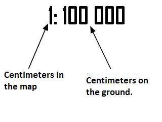
  • Graphic scale.It consists of a straigh line divided into segments. Every segment is equivalent to a real distance in the ground.
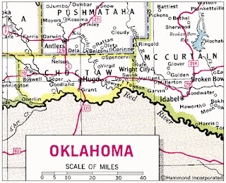
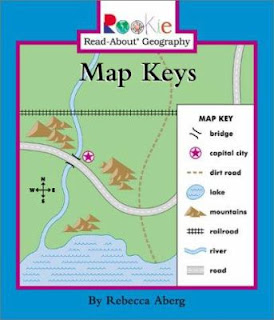
Legend or key of the map: is a set of colours, standar signs or symbols used to represent reality in the map in a simplified form.
Types of maps:
There are two types of maps:

  • Topographic or basic maps: represent in detail the physical and human aspects of the territory.
  • Thematic maps: represent a specific geographica aspect.

No hay comentarios:

Publicar un comentario